Lucent at Cary |
From Lucent, took Rt 64 across Jordan Lake, then 87 to 40 to 421 to Wilkesboro. Wilkesboro has Tyson foods, a huge chicken processing factory in its center. It is not an attractive city. From Wilkesboro, took Rt 16 towards the parkway. For a while, I branched off to the right of Rt 16, onto Old Rt 16. There were some pretty spots which were spoiled by high tension lines. Most of the houses were unimpressive.
Jordan LK rt64 |
OldRt16 |
OldRt16 |
Drove a while along the parkway and then exited to the west at Glendale Springs. Stayed at Crystal Spring Inn . The terrain was very pretty, not steep hills. But at over 3000 feet it often gets snow in the winter. And it did snow that night.
BlueRdg |
BlueRdg |
BlueRdg |
BlueRdg |
CrystalSpringInn |
Took 115 back to Wilkesboro. On the way, took these pictures.
Rt115 |
Rt115 |
From Wilkesboro, took Rt 268 to Elkin and then Rt 77 north to Mr Airy which is close to the Virginia border.
Mt Airy |
Mt Airy |
Passed into Virginia on a back road and came upon a view much like we see of Mt Whiteface.
Pkwy bottom |
Pkwy bottom |
Passed over the parkway and came to a winter wonderland .
West of Pkwy |
West of Pkwy |
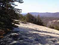
Made a side trip to Stone Mountain, which is a very nice park for both camping and hiking. I hiked up the mountain, perhaps 1 hr up and ½ hr down. At the top, there is just a steep treeless ledge to climb. A little scary, especially on the way down, but the view was well worth the excitement. On the way down a saw some deer.
StnMtnEntrance |
stone mtn |
stone mtn |
stone mtn |
stone mtn |
stone mtn |
deerStnMtn |
Continued west on Rt. 21, crossing over the parkway which was closed. I'm glad the parkway was closed because the scenery tends to be better off the parkway than on it. On the parkway, there are lots of trees to block the view. Of the Parkway, you get to appreciate the many fields better. And looking back to the ridge is a pretty view. To return east, I took R18, which I think is prettier and has nicer dwellings than Rt 16.
The Rt 21, Rt 18 circuit is a GREAT loop.
%20Lucent%20at%20Cary.jpg)

%20OldRt16.jpg)
%20OldRt16.jpg)
%20BlueRdg.jpg)
%20BlueRdg.jpg)
%20BlueRdg.jpg)
%20BlueRdg.jpg)
%20CrystalSpringInn.jpg)
%20Rt115.jpg)
%20Rt115.jpg)
%20Mt%20Airy.jpg)
%20Mt%20Airy.jpg)
%20Pkwy%20bottom.jpg)
%20Pkwy%20bottom.jpg)
%20West%20of%20Pkwy.jpg)
%20West%20of%20Pkwy.jpg)
%20StnMtnEntrance.jpg)
%20stone%20mtn.jpg)

%20stone%20mtn.jpg)
%20stone%20mtn.jpg)
%20stone%20mtn.jpg)
%20deerStnMtn.jpg)